A Rising Interest in Emergency Event Support
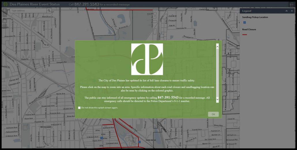
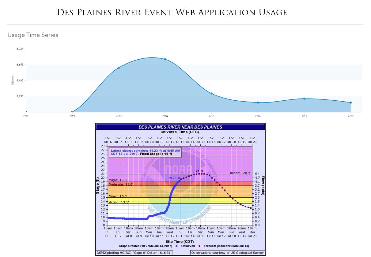
On July 12th, 2017 the City of Des Plaines had one of the biggest river events in their history. A series of storms moving through the Midwest caused the Des Plaines River to rise nearly 7 inches over the action flood stage, making it the fourth largest crest on Des Plaines records. Thankfully, due to the proactive actions taken by the Des Plaines Emergency Operation Center (EOC), the GIS Department was able to work with the EOC and Media Services Department to visualize the affected areas and road closures, and indicate where sandbags were placed and could be picked up. The impact of this collaborative effort was that the City was able to maximize resident safety and outreach, and minimize property damage that was widespread in the 2008 and 2013 Des Plaines floods.
Visualizing the Data
The primary responsibility of GIS during a flooding event is to help visualize data in order to assist EOC staff to make important decisions. This includes utilizing an application to inform residents of the following:
- Road closures
- Areas with high chance of flooding
- Sandbag placement
- Sandbag pickup locations
Going Above and Beyond with Updates
To visualize this data, GIS created a web application to show road closures and sandbag locations, and to provide emergency contact information for those in need. The City wanted to ensure that residents were consistently receiving the newest information. In order to accomplish this, the EOC, the Public Works Department, the Media Services Department, and the GIS Department worked continuously to relay the most recent information. Public Works would communicate information to the Media Services Director, who would forward the information to GIS and draft a press release identifying the new information. This collaboration among departments allowed the City of Des Plaines to be highly effective in providing flood relief and support to their City.
As the Waters Rose, So Did Views of the Application
To most effectively communicate this information to the public, the interactive web application was added to the City’s homepage. From July 12th to July 26th, the application had 26,906 views. From the 12th to the 15th at the peak of the flooding impact, 5,400 people viewed the map each day. Efforts during the flood event clearly identified that technology could not have been the standalone solution for solving this problem. The collaboration between the GIS Specialists, MGP, the EOC staff, and Media Services created a sustainable model that can be replicated in other GIS Consortium communities with similar needs pertaining to Emergency Management.
Maintaining Momentum
The significant impact of this project was not overlooked by the City. It not only shows the value that GIS can bring to a community, but also what interdepartmental collaboration can do to increase the efficiency of local government. Another meaningful outcome from this project was increased trust. This highlighted the fact that GIS is a reliable source when called upon in an incredibly important situation. This trust is then carried on to other projects. A direct example of this was days after the crest of the flood. GIS was approached with the question, “Can we use GIS to collect, maintain, and send damage assessments to FEMA and IEMA?” Within a day, GIS created a product that would allow for such capabilities and made it available to all GIS Consortium Members. This is another great example of how collaboration can fuel innovation without the need to reinvent the wheel.
Take the Lead
The ability to predict emergency events is very difficult. This is why Emergency Operation Centers take the time to proactively plan for all types of emergencies to ensure that communities and their residents are ready when the time strikes. Contact your GIS Specialist to discuss how your EOC can work with GIS to maximize the safety and preparedness in your communities.
If you would like to learn more about this initiative or if you have questions, please contact agrahovac@mgpinc.com.
Author: Mitch Greenan, GIS Specialist

